

Working File 1
PURPOSE: To submit documentation for MVCA order, continue to explore site plan control.
Refer to revision notes to links to review versions.
MVCA SUBMISSION

SCOPE OF SUBMISSION
For the unauthorized realignment, hydrologic, hydraulic and fluvial geomorphology studies will be required demonstrating no change in flooding or erosion along the property and to the neighbouring upstream and downstream properties
SCOPE OF FLUVIAL GEOMORPHOLOGY
Existing and post development watershed delineation
Derivation of channel design flows, including the 100-year flow
Existing and post development flood elevations and channel flow velocities
Existing and post development 100-year floodplain delineation (must demonstrate all grading and development is outside of the 100-year floodplain)
Natural channel design (channel morphology: sinuosity, riffles/pools, bank and bed stability/material selection and size, erosion analysis)
Channel alignment plan, channel geometry and cross-sectional drawings
Channel and bank protection details
Longitudinal profile with Hydraulic Grade Line (HGL)
Sediment and erosion control plan
Landscape plan
Post construction monitoring and maintenance plan
SCOPE OF CIVIL ENGINEERING
Site stormwater conveyance/management
Existing and post development grading plan
Existing and post development drainage plan and floodplain delineation
CHECKLIST
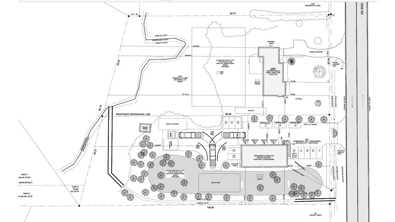
SITE PLAN
We will need to update site plan according to morphology; parking lot planning etc.
REVISION NOTES
-
2026-01-07
-
-
26-02-10
Meeting with MVCA re: watercourse
Verified regulatory mapping as well as watercourse definition.
Need to define 100 yr flood line, design stable channel. Slope stability of existing ditch - site plan will need to design for plantings to stabilize new river beds and minimize further disturbance.
Attendees:
Rachel Clouthier, Rikke Brown, Shelley Groenc, Sandra Swift, Amanda Sanford, Peter Hackenbeck
-
FLUVIAL GEOMORPHOLOGY
-
-
2026-01-07
-
26-01-23
Follow up <EMAIL> with conservation
-
26-02-02
<EMAIL>
-
26-02-10
Follow up meeting after meeting with MVCA.
Next steps - begin conceptual mapping. Amanda to provide revised site sketch. Estimate for site grading and storm water management to follow.
Attendees: Sandra Swift, Amanda Sanford Shelley Groenc
CIVIL ENGINEERING
ARCHITECTURAL
No revisions required through site plan control, may require some adjustments for the conversion of use permit.
STRUCTURAL
No Structural review required at this phase.
REVISION NOTES